Recovery reminiscence and hope
The last four months have not been been the most memorable in my life, twelve weeks hampered by toting a catheter around followed by an Op and four weeks of no lifting, "Drinking" or strenuous exercise. Yes walking was possible but unpleasant, nevertheless i managed three fairly decent outings in Galloway. Thats all changed and I am back on a daily 5K brisk walk and morning exercise, press ups have become a lot easier now what with my 10% weight loss.
Anyway enough rambling, during that time I took the opportunity to sort many of my monochromes into some sort of order. In doing this it soon became apparent that i have returned to certain locations many times over the past however many years. One of those locations is Kentmere mainly for two reasons, first it's the nearest Lakeland Dale to home, and secondly it's a dead end with no amenities to attract anyone other than the serous walker, so usually quiet. Also no longer relevant to this octagenarian it used to be a place fully suited to my other love of mountain Biking.
So what follows are some of my favourite images taken on the many times both I and also Barbara have done the Horseshoe and some of the many other computations that are possible around and along the valley. These have been arranged as if I were doing the Horseshoe in an anticlockwise direction but obviously not all taken on the same day or even in the same direction.
A telephoto shot from the Cornclose Track into the Dalehead
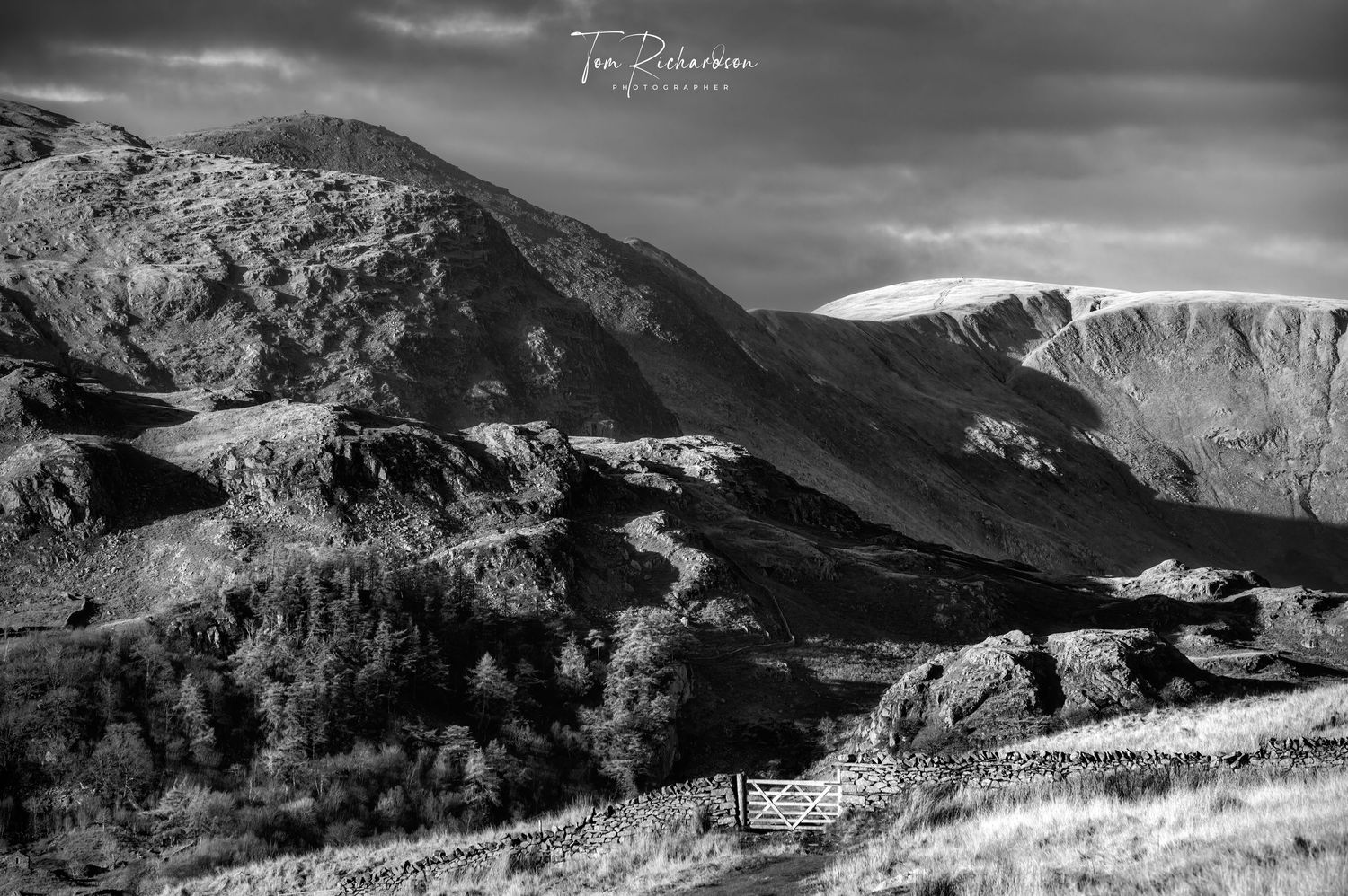
Although not actually taken from the usually recognised route of the horseshoe this shot gives a good idea what the west and most rugged side of the valley is like. Taken from the track down from Skeggles Water and looking across Rowantree Knott and Castle Crag to Rainsborrow Crag, with the cairn on Ill Bell showing at the top of the photo and then just the tip of Froswick before the track up to Thornthwaite Beacon. The prominent gulley to the right of the beacon makes a great alternative descent into the head of the valley as does that of Hall Cove out of sight on the Right.

Cottage at Green Quarter and Kentmere Church
The path uphill from either the few parking spaces by the church or the overspill car park passes by this cottage at Green Quarter before continuing along the bridlepath to Sadgill in Long Sleddale. The horseshoe circuit leaves the bridlepath at the watershed, heads north and climbs to Shipman Knott with then follows the broad ridge up to Kentmere Pike with 3.5 miles already covered.
This particular shot was taken in 2022 but my first ever was taken back in 1986 on a Bronica ETRS medium format camera and was one of my most successful prints, a copy of which was hung in Ilford's offices for a number of years.

Barbara on the summit of Kentmere Pike
I cannot honestly say this blog is really about the Kentmere Horseshoe without having an actual photograph of Kentmere Pike in it , yet in reality its summit is perhaps the most uninteresting part of the round and hardly worthy of a photograph.
So I have included this shot of Barbara taken eight years ago, cooling her feet by the summit. The next 2 Km along the watershed wall to the summit of Harter Fell can clearly be seen in the background.

Looking down to Small Water from Harter Fell
The interesting part of the circuit really begins with Harter Fell and this view north over Small Water and Piot Crag to High Street and Kidsty Pike, in my opinion is one of the best views in Cumbria. I have taken this shot many times over the years and even been lucky enough to see a Brocken Spectre "Twice"
From Harter Fell the next peak along the footpath seen here on the LHS descends to Nan Bield pass then climbs up to Mardale Ill Bell about a mile away.

Small cairn on Harter Fell looking east.
This small cairn marks the the start of the descent from Harter Fell to Nan Bield Pass. Photographed looking east over the whaleback of Lingmell End with the sun shining on it to the slopes of Froswick our return route on the far side of the valley.
To put the shot into context Lingmell End is the prominent steep conical hill seen towering behind the reservoir when looking up the dale.

Looking south from the slopes of Mardale Ill bell down to Nan Field.
Looking back down from Mardale Ill Bell to Nan Bield Pass and the climb up Harter Fell. The track dropping down on the left leads from Overend in Kentmere across the col and past Small Water to the road end at Haweswater. Of all the mountain passes in Lakeland Nan Bield most fits the perception of what a one should look like, even down to the tiny shelter on its narrow summit col.

Another shot looking across Nan Bield to Harter Fell
The Beacon on Thornthwaite Crag
From Mardale Ill Bell to Thornthwaite Crag a distance of about 2Km the path curves round Hall Cove one of Lakeland's hidden valleys and source of The River Kent. Whilst it is not necessary to go to the beacon as the path by-passes it most purists will go out of their way to pay a visit as the views down into Thresthwaite Mouth are well worth it.
Hall Cove also makes yet another interesting route of ascent, a steep and lonely place where on one visit we encountered a herd of Red Deer and a later higher up another group of Fell ponies. On another occasion we were treated to the appearance of the Riggindale Eagle.

Froswick and Thornthwaite Crag
Winter on the horseshoe. Looking over the shoulder of Ill Bell to snow capped Froswick and Thornthwaite Crag.
The scree filled gully between Thornthwate Crag and Gavel Crag is yet another interesting way onto the Horseshoe although much better in descent than ascent.

Thornthwaite Crag from Froswick.
A dramatic shot of Stony Cove Pike, the deep gash of Threshthwaite Mouth and Thornthwaite Crag seen from below the summit of Froswick, approx a mile distant.

Summit Cairn on Ill Bell
The summit cairn on Ill bell. This is not the only cairn on the tiny summit there have been others here whose locations and shapes have changed over the years, at least that is in my memory, but this one remains. Thornthwaite Crag and Stony Cove Pike 3Km away to the right of the cairn are catching the last rays sun.
From here after passing the last nail in the Horseshoe, the tiny peak of Yoke, the easiest way to cover the 3.75 miles back to the start at Kentmere Church is to first drop down to the summit of Garburn Pass, and use that for the rest of the descent.

A misty day on Ill Bell
Not all fell walks turn out to be photogenic or even pleasant, some like this visit some ten years ago become epic's of endurance. My title states it was misty but in reality it was cloud followed by wind and then torrential rain so much that by Thornthwaite i'd had enough. So even though I know the area well discretion still took the better part of valour and I beat a retreat down the scree gulley mentioned earlier.
These old straining posts which once appeared all along the ridge have gradually rusted away over the years, the cairn on the summit of Harter Fell was once a modern art form composed nearly entirely of their bent and twisted remains.

Spindrift on Yoke
Yet another form of weather to contend with sometimes, stinging spindrift, seen here blowing over the shoulder of Yoke. However I have to admit this shot was taken from the valley floor near Hartrigg.

Garburn Pass
Looking down into Kentmere from the Garburn Pass. My first encounter with the pass came way back in the 60's on a winter club run with West Lancs RC, sprung forks etc hadn't even been dreamt about back in those days, we dragged old steel bikes adapted slightly with heavier wheels over most of the passes in Lakeland. Great fun which was once featured in The Blackpool Evening Gazette, it kept us race fit for the next season though.

The last feature before returning to The Church is The Badger Stone.
Perhaps the largest boulder in Lakeland "The Badger Stone" has been a target for rock climbers for as long as I can remember. The Garburn track passes just above it before returning back to the start of the Horseshoe at Kentmere Church..
The full horseshoe is approx 20Kms (12 1/2 Mls) in length and total ascent is 1006 Mtrs (3,300ft), and has been run in 1 hour and 22mins. Many years ago tried to do it in under 4Hrs walking the uphill bits and running the downs missed out but not by much.